Conversation
worldengine/generation.py
Outdated
There was a problem hiding this comment.
I added in values for the different mountain-levels. The percentages, however, are merely guessed so far. I could use some better suggestions on those ( @ftomassetti maybe? Also, @esampson seems to know things like these).
There was a problem hiding this comment.
As a note: Neither these values nor the corresponding functions in World.py have really been used before (maybe in one or two places). So this shouldn't cause terribly broken code and might offer some opportunities for future improvements to some of the generation-algorithms.
87aef2a to
8180b2e
Compare
There was a problem hiding this comment.
Is it problematic to add the new variables in the "middle" instead of the end?
There was a problem hiding this comment.
well, that breaks compatibility but in this case I would say it is intended
…amic.

Updated World.proto and World_pb2.py.
8180b2e to
5b9b83b
Compare
worldengine/generation.py
Outdated
There was a problem hiding this comment.
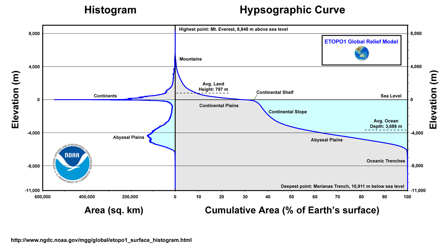
I picked these values after inspecting the results of #203 and Earths hypsographic curve. The real world seems to follow something like 2^x according to that graph.
|
I updated this one to make it use values that are close to Earth's. I am now satisfied with the results, the satellite-output looks almost like it did before - but everything is tied to the worlds mountain-thresholds (and could be globally changed) instead of fixed in the code. :) |
|
Restarting tests |
worldengine/generation.py
Outdated
There was a problem hiding this comment.
50% isn't a lot? It is based on real data?
There was a problem hiding this comment.
50% of only the land. "Hills" to me sounds like those small bumps in the world - 50% sounded reasonable. What would you suggest?
I basically tried to emulate this:
And that seemed like 2^x to me.
There was a problem hiding this comment.
I think we could use the definition of hill as 300m of elevation. I am not sure if it is w.r.t. to the surrounding terrain or to the level of the sea. I am looking for more precise data. to understand better
There was a problem hiding this comment.
Looking at the two images above, the scale of the platec-world to Earth seems to be roughly 1000:1. So hills right now are at roughly 1000m (wrt. sea-level) - the value would be lower if the first part of the graph wasn't as steep as it is.
You said 50% seemed like a lot. Moving hills down will increase that number even further - to maybe 75%.
The graphs can probably be used to find reasonable values. Although the definitions of hills, mountains etc. are kind of arbitrary at the moment.
There was a problem hiding this comment.
Hill used to represent the top 10% of all the world, if land is 1/3 of the world it means they used to ~33% of land, right? So that mean we are getting 50% more hills than before. Mountains should roughly stay the same instead (if I am not wrong)
There was a problem hiding this comment.
Actually my former comment in the code was off: Plains used to be the top 10% of the world (total), hills only the top 3% (total). The current value pushes that to 15% (total). So if we wanted less, we should pick a base other than 2...so more like 10^x? That sounds very drastic to me. The values would be [0.95, 0.10, 0.01, 0.001, 0.0001].
Don't forget, though, that hills were the highest portion of the world before the new levels were added. From that point of view it might be perfectly fine to have 50% (of land) be hills and maybe equate the new medium mountains with the former hills. (Or something along those lines.)
There was a problem hiding this comment.
The first two plots in #203 show the difference of the values pretty nicely (old levels first, then new levels). The new hills are below the old plains. The old hills are roughly where the new medium mountains are.
There was a problem hiding this comment.
I just checked something: Look at the first image in swipe-mode.
Doesn't really tell anything about the quality of the chosen values, only that I should check if the ancient maps need a little tweak to make use of the new levels.
(Also, check the biome-map in swipe-mode - there is quite a bit of fine detail added due to the height-levels! It's caused by the temperature-map, which does include an altitude-factor.)
The values themselves seem pretty good to me; the old ones seem much more sketchy, with hills being the substitute for a proper mountain-level. Once we agree on good values, I will check the three places that actually make use of them (river-generation, temperature-generation and ancient map-generation). I think there is some detail to be gained in those. :)
|
Also: There is data that comes with this, Mindwerks/worldengine-data#17. EDIT: Right, the world-file cannot even be loaded due to the new variables. |
7f4cd4f to
a230771
Compare
While I was at it I thought I might make the new satellite-map use the proper mountain-heights instead of the ones defined in draw.py - that way the output should coincide better with the other maps.
I then noticed that the mountain-thresholds were kind of improperly used. Hills were used as mountains and the higher mountainous areas probably never existed in any world because the values were too high.
Data for this PR can be found here.